Dear Editor,
One of the primary goals of society’s development is providing good public health. The health indicators can measure the progress of human development toward sustainable development (1). However, significant population growth coupled with global environmental crises such as climate change, degradation of natural ecosystems, soil erosion, and environmental pollution have led to the spread of many diseases, and even rising new diseases (2). Also, studies have shown that global warming raises natural hazards such as floods, hurricanes, and firing may result in intensifying some diseases (3). This letter aims to clarify the relationship between the environmental factors and disease dispersion and also discusses the important applications of remote sensing and spatial analysis techniques in knowing the environmental state.
Diseases spread are associated with the environmental and biophysical state. For instance, in high-temperature areas, the body needs more water; thus, the use of contaminated water can cause water-borne problems, especially in areas where access to clean water is difficult (2). Humidity is another example of the climate condition in which the high rate of humidity prevents the body from sweating, result in fungal skin diseases (4). Also, topographical situations including slope and steepness, aspect, altitude, vegetation cover, and land-use patterns, can influence the dispersion of disease. Advance progresses in remote sensing techniques, and spatial analysis are significantly helpful in understanding the relationship between disease dispersion and environmental factors, in addition to locating and forecasting outbreaks of diseases (4). Information on environmental factors helps to identify the habitats of disease vectors based on their ecology. This information can be obtained through high-resolution satellite data, and therefore, contaminated areas can be tracked, and ultimately the epidemic will be prevented by creating early warning systems (5).
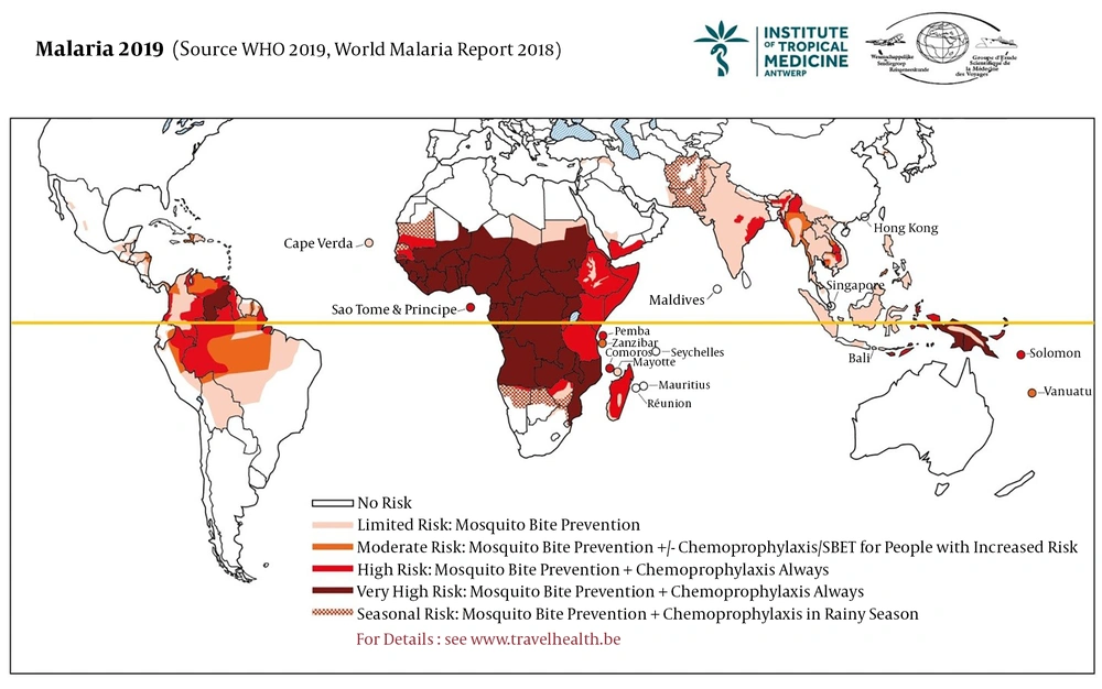
Some infectious and non-infectious diseases such as malaria, meningitis, cutaneous leishmaniasis, cholera, and cancer have been monitored through satellite data. World health organization (WHO) has recently reported the global status of malaria. In Figure 1, the global risk of the malaria outbreak is shown (1). This infectious disease mainly spread in the tropical and subtropical regions that annually affects millions of people in the world. Based on the figure, most African countries have a high rate of malaria infection that is caused by anopheles mosquito. The distribution of Anopheles can be predicted using environmental and climatic conditions such as vegetation cover, waters bodies, population density, soil moisture, and temperature.
Worldwide distribution of Malaria Outbreak in 2019 (1)
In conclusion, remote sensing and spatial analysis are important techniques for public health, medicine, and healthcare studies. These techniques should be used together in connection with modeling techniques. Mainly, these techniques have widely been used to support monitoring, forecasting, and control diseases. This current letter has highlighted the importance of remote sensing and spatial analysis techniques in order to the widely use of these techniques in public health, and especially the role of environmental factors on disease dispersion. However, the manuscript is only a letter which is not revealing that detail of the remote sensing contribution in the health sector. Therefore, it will try to expand this letter to a review paper that would present much detail in this issue and applying remote sensing techniques to improve human health.

